
America—A Nation of One People from Many Countries

| Maker | Emma Cartwright Bourne (American, 1906–86), designer; The Council Against Intolerance in America, New York City, publisher; Davidson Printing Corporation, New York City, printer |
| Date of Creation | 1940 |
| Location | New York City |
| Materials | Offset lithograph: Paper, ink |
| Institution | The Wolfsonian–FIU |
| Credit Line | The Wolfsonian–FIU, The Mitchell Wolfson, Jr. Collection of Decorative and Propaganda Arts, Promised Gift |
| Accession Number | WC2008.10.14.12 |
| Photo Credit | Lynton Gardiner |
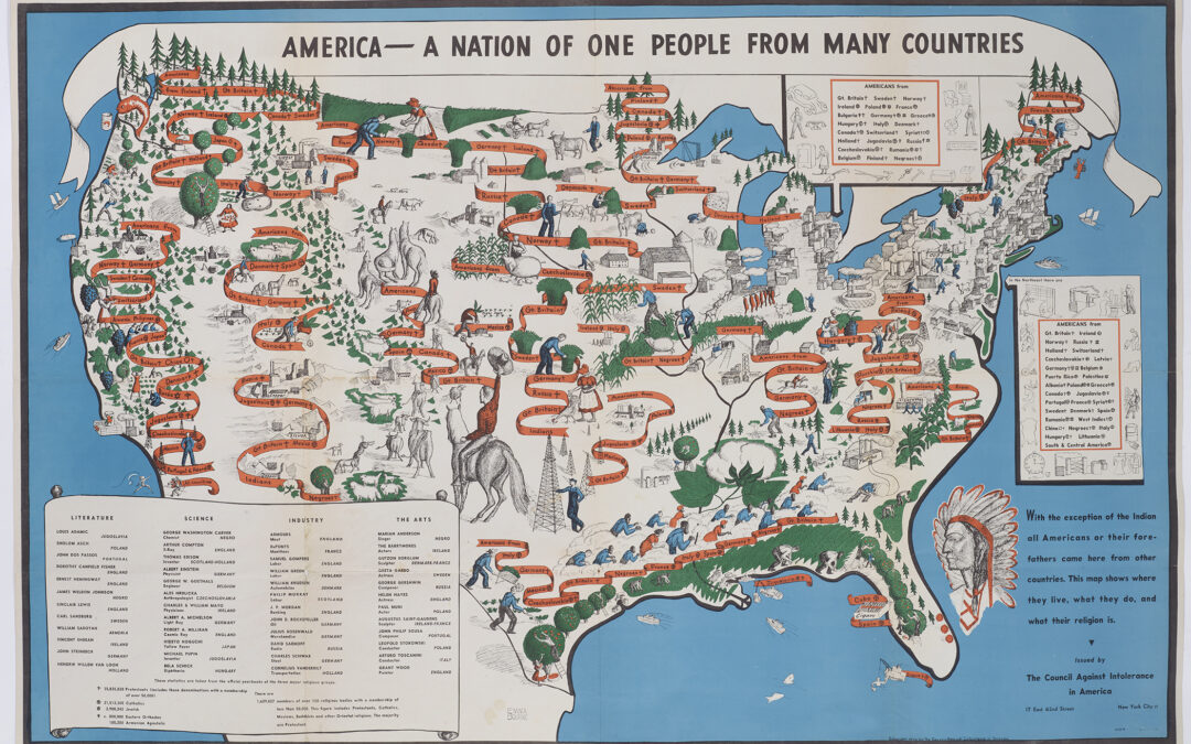
Published the year before the United States entered World War II and in response to a rise in anti-immigration sentiment, this map reflects a critical moment as the nation grappled with the idea of unity. The newly established Council Against Intolerance in America which sought “to counteract the propaganda of racial and religious prejudice” commissioned this map for distribution in schools and community centers throughout the country. Gertrude Albion MacCormick, a Council employee and former research librarian at the Library of Congress, assembled the data used in the map in what was reported to be a pioneering effort. Connecticut-born printmaker and painter Emma Cartwright Bourne then created a visual representation of the continental United States, removing state borders to portray a unified land and adding cascading ribbons that listed immigrant groups, their country of origin, and religion. The map, designed for an educational purpose and didactic in nature, includes drawings denoting various regional industries and references 35 nationalities and 48 distinguished immigrants who made contributions to literature, science, industry, and the arts. The list includes Ernest Hemingway, John D. Rockefeller, George Gershwin, Greta Garbo, and Albert Einstein, who had just recently become a citizen. Yet despite the makers’ worthy intentions, the map fell short in its mission, most notably in its representation of Native and African Americans. Instead of their depiction in the map, Native Americans were only referenced by the disembodied head of an Indian chief, literally separated from this vision of America and displaced off the coast of Florida. African Americans were relegated to the South, laboring in cotton fields. While other immigrants were identified by their country of origin, the two celebrated African Americans listed— George Washington Carver and Marian Anderson—were cited as “Negro,” a substitution of race for location.