
Map
Home > Maps, Prints, and Paintings > Map

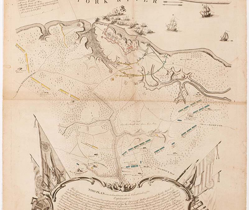
| Maker | Cartographer Sebastian Bauman (1739–1803), Engraver Robert Scot |
| Date of Creation | 1782 |
| Location | Philadelphia, Pennsylvania |
| Materials | Line engraving with hand coloring on laid paper |
| Institution | The Colonial Williamsburg Foundation |
| Credit Line | Gift of Mr. and Mrs. Richard F. Barry, III, Mr. and Mrs. Macon F. Brock, Mr. and Mrs. David R. Goode, Mr. and Mrs. Conrad M. Hall, Mr. and Mrs. Thomas G. Johnson, Jr., Mr. and Mrs. Charles W. Moorman, IV, and Mr. and Mrs. Richard D. Roberts. |
| Accession Number | 2017-238 |
| Photo Credit | Colonial Williamsburg Foundation |
As soon as the surrender flag was raised, Washington dispatched his engineer, Sebastian Bauman, to survey the Yorktown battlefield. This map was the result of that exercise and features an interesting artistic composition. Yorktown, Gloucester Point, and troop positions are confined to the top half. The lower half is dominated by the explanation of the locations depicted. The kidney shape of the Rococo scrollwork cartouche surrounding the explanation, with flags and banners that thrust upward from both sides, force the viewer’s eye to the center of the map, which is unembellished and unobstructed yet delivers a powerful message. The whole composition was created to highlight the tiny inscription at the center of the map, “the field where the British laid down their arms.” Bauman dedicated the map to Washington, having documented the spatial range of the battle that concluded the American Revolution.